Navionics Platinum+ XL Chart • 5P397XL Eastern UK
Sorry this item is no longer available
For those who want to know more, Platinum+ charts offer the same content and features of Navionics+, while adding the Relief Shading, 3D View, Panoramic Photos and the new satellite overlay with SonarChart Shading Layer. Platinum+ charts are available in both Small and Large coverage areas (the detail is the same in both).

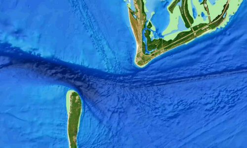
Relief shading
Easily Interpret Bottom Structure
Relief shading delivers highly detailed shading that combines colour and shadow to provide an easy-to-interpret, clearer view of bottom structure than contour lines alone.

Identify Topography Quickly
For coastal and inland boat owners who need to know as much as possible about sea and lakes beds, relief shading offers a better understanding of bottom detail for improved fishing and diving.
In some cases, high-resolution data is mixed with low-resolution data to produce a more complete image. The most convenient way to preview relief shading in your area of interest is on the Navionics Boating app.

How to Get Relief Shading
Included as a downloadable option with Platinum + cards, it can be viewed with compatible models from many brands.
Click here for chart compatibility
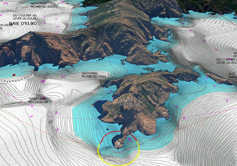
Satellite Overlay with SonarChart Shading
Gives a unique perspective of underwater topography at a glance. Created from the high-definition contour data within SonarChart, Navionics shading presents a detailed rendering of the seafloor and lake bottoms in varying shades of blue.
3D View
Dynamic 3D View allows you to customize your chart to highlight key features for a better awareness of your surroundings.
Panoramic Photos

Panoramic photos give a better sense of the surroundings so you can evaluate your options.
The Navionics subscription
A one-year subscription to Daily Updates and advanced features is included when you purchase any new product.
After a year, you can renew at a discounted price
Please specify the make & model of your chartplotter when ordering, so we can supply the chart in the correct format
This item is currently not in stock but is available to preorder, with a lead time of up to 14 days.
This item has been discontinued and is not available to purchase.
Our Mail Order team ship chandlery, yacht parts and sailing clothing around the world. We use the best value couriers available, and we will endeavour to get your products to you as quickly and as cost effectively as possible.
International Orders: International shipping charges will be calculated and advertised at checkout. Pricing may vary. International orders must be placed online and from a location outside of the UK. Our mailorder team are unable to facilitate the placement of international orders.
UK Standard Delivery
- UK Mainland 0 - 2Kg (small jiffy) £3.95 Royal Mail Service. Despatch within 3- 5 working days, delivery in 7-10 working days for orders under £100.00. This is an estimated delivery window from our chosen courier.
- UK Mainland 0 - 30KG £5.95 Courier service with signature. Despatch within 3- 5 working days, delivery in 7-10 working days. This is an estimated delivery window from our chosen courier.
- UK Mainland 0 - 30KG OVER 1.2m LENGTH £15.95 Courier service with signature. Despatch within 3- 5 working days, delivery in 7-10 working days. This is an estimated delivery window from our chosen courier.
- UK Mainland 30KG+ Price on request
- UK Mainland Next Day 0 - 30KG £9.95 Courier service with signature, orders must be placed before midday. This is an estimated delivery window from our chosen courier.
- UK Mainland Next Day 0 - 30KG OVER 1.2m length £19.95 Courier service with signature, orders must be placed before midday. This is an estimated delivery window from our chosen courier.
- UK Mainland Saturday 0 - 30KG £19.95 Courier service with signature, orders must be placed before Friday. This is an estimated delivery window from our chosen courier.
- Northern Ireland, Highlands & Islands 0 - 2KG (small jiffy) £3.95 Royal Mail Service. Despatch within 3- 5 working days, delivery in 7-10 working days for orders under £100.00. This is an estimated delivery window from our chosen courier.
- Northern Ireland, Highlands & Islands 1 - 30KG £10.95-£14.95 Courier service with signature. Despatch within 3- 5 working days, delivery in 7-10 working days
- Northern Ireland, Highlands & Islands 1 - 30KG OVER 1.2m length from £24.95 Courier service with signature. Despatch within 3- 5 working days, delivery in 7-10 working days
- Northern Ireland, Highlands & Islands 30KG+ Price on request
- Channel Islands 0 - 2KG (small jiffy) £5.95 Royal Mail Service Despatch within 3- 5 working days, delivery in 7-10 working days for orders under £50.00
- Channel Islands 1 - 30KG £19.95 Courier service with signature. Despatch within 3- 5 working days, delivery in 7-10 working days
- Channel Islands 30KG+ Price on request
UK Exceptional Delivery
- UK Mainland; Antifoul & paints £5.95
- UK Mainland; Inflatable dinghy £10.00
- UK Mainland; Liferafts £29.95
- UK Mainland; Flares £49.95
- Northern Ireland, Highlands & Islands; Antifoul & paints £9.95
- Northern Ireland, Highlands & Islands; Inflatable dinghy price on request
- Northern Ireland, Highlands & Islands; Liferafts price on request
- Northern Ireland, Highlands & Islands; Flares not available to ship at this time
- Channel Islands; Antifoul & paints £16.95
- Channel Islands; Inflatable dinghy price on request Channel Islands; Flares not available to ship at this time
Ship to Store service; You can now order from our website for collection from one of our 8 Force 4 locations. Simply select “Ship to Store” at checkout and your goods will be ready for collection within 5 working days. This service is free however may exclude some hazardous or special order goods.
For further delivery information click here.
Standard Returns
If you are not entirely happy with your purchase, we will exchange or refund your goods in full, provided that the items are returned within 14 days of receipt.*
Please check the condition of goods on arrival - we are unable to accept goods damaged during shipping after 14 days.
Returned goods must be packaged securely, with all original packaging undamaged and in a saleable condition i.e. shoe boxes must be in the same condition as when received.
Goods must be unused and security seals intact.*
If you would like to return goods because they were ordered incorrectly or if clothing does not fit, return postage will be at your expense. If you would like us to replace the goods with another size or colour, we will charge carriage on the replacement.
Please be aware that some navigational and safety products may be dated, and as such a full refund may in some cases not be possible. If you are purchasing dated navigational charts we suggest you contact us for more information.
Faulty Goods
If you receive your goods and believe them to be faulty, please contact us straight away with a brief description of the problem. If we require you to return the product for a replacement, we will send you a pre-paid Royal Mail label for delivery back to us. Unfortuantely we cannot send the courier back to collect the items.
Returning goods to Force 4 is easy!
- Please contact us by ringing 0345 1300 710 or email on [email protected]. This way we'll be able to determine whether you would like to return the product for a refund or whether you'd like to exchange the product. We are unable to process the return of faulty goods that we're not expecting.
- We'll then give you a returns number. This returns number will need to be clearly marked on the outside of your parcel so it can be identified on arrival. Please note, failure to mark a returns reference number on the outside of your parcel may result in a delay in processing your return.
- Don't forget your proof of postage, just in case!
- Once we receive the item we'll be able to proceed with a refund or an exchange.
*this excludes faulty goods with manufacturers defects. If goods are found to be faulty during use, after the returns period, please just give us a ring on 0345 1300 710 and we'll be happy to help.
Stock Alert
Please alert me via email when this product is back in stock.
Ask a question
Men's Size Guide
| To Fit Height | To Fit Chest | |
|---|---|---|
| X SMALL | 5'2" - 5'4" | 34 - 36" |
| SMALL | 5'5" - 5'7" | 36 - 38" |
| MEDIUM | 5'7" - 5'10" | 38 - 40" |
| LARGE | 5'11" - 6'1" | 41 - 43" |
| X LARGE | 6'1" - 6'3" | 44 - 46" |
| XX LARGE | 6'3" - 6'5" | 46 - 48" |
Shoe Sizes
| UK | EURO | MENS US | LADIES US |
|---|---|---|---|
| 3.5 | 36 | 5.5 | |
| 4 | 37 | 6 | |
| 4.5 | 37.5 | 6.5 | |
| 5 | 38 | 5.5 | 7 |
| 5.5 | 38.5 | 6 | 7.5 |
| 6 | 39.5 | 6.5 | 8 |
| 6.5 | 40 | 7 | 8.5 |
| 7 | 40.5 | 7.5 | 9 |
| 7.5 | 41.5 | 8 | 9.5 |
| 8 | 42 | 8.5 | 10 |
| 8.5 | 42.5 | 9 | |
| 9 | 43 | 9.5 | |
| 9.5 | 44 | 10 | |
| 10 | 44.5 | 10.5 | |
| 10.5 | 45 | 11 | |
| 11 | 45.5 | 11.5 | |
| 11.5 | 46.5 | 12 | |
| 12 | 47 | 12.5 | |
| 12.5 | 47.5 | 13 | |
| 13 | 48 | 13.5 | |
| 14 | 50 | 14.5 |